EDUCATION & SKILLS ›
Mapping and 3D visualization of forest fuels using high resolution satellite images and geo-informatics techniques for fire management
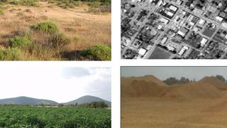
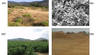
Fuel mapping is essential for fire management, particularly for assessing the hazard of a fire and the risk of its occurrence in an area, as well as for simulating its spread and intensity across the landscape. However, fuel mapping is an extremely difficult, expensive and complex process that requires specialized knowledge in a) high-resolution satellite image analysis, b) fire behavior, c) landscape ecology, d) fuel modeling and e) geographic information systems. This study maps fuel and fire behavior parameters (speed of spread, flame length, thermal front intensity) in the area of the Amali Peninsula (Prefecture of Lesvos) using geoinformatics, fire behavior simulation programs and statistic methods on a spatial data base. The ultimate goal is the creation of allometric equations for the estimation of the biomass of shrubs and trees and their application in space, once the independent variables are calculated through satellite images. Finally, the 3D visualization of the fuel models contributes to a better understanding of the fuel allocation and the simulation of the phenomenon of forest fires. The results of this study include the estimation of shrub and tree biomass using allometric equations, the development of a methodology to estimate biomass directly from high-resolution satellite imagery, and the creation - mapping - 3D visualization of fuel models representative of the study area using actual measurements. The methodology and results of cartographic modeling are of research and practical interest in supporting decisions regarding the prevention and suppression of forest fires.
GRANTS
EDUCATION & SKILLS

Postgraduate Scholarships Programme | Academic Year 2024-2025

“Latsis Foundation Study Abroad Scholarships” Programme | Academic Year 2023-2024
The American College of Greece

Secondary Education Scholarship Programme
Anatolia College

«STEAMing the Future» Programme | School Year 2024-2025
Anatolia College

“Skills Clubs | Youth Skills for the 21st Century” | School Year 2024-2025
British Council Greece

«Company Junior» and «V-Company» Programmes | School Year 2023-2024
Junior Achievement Greece

“Future Leaders Series” Programme | 2024
ALBA Graduate Business School

Educational Visits to the “Ocean Lab” Educational Space | School Year 2023-2024
Safe Water Sports

Support of Educational Programmes & Screenings
The Goulandris Museum of Natural History

“Eco-Schools” Programme
Hellenic Society for the Protection of Nature

“Tech Talent School for Educators” Programme | School Year 2023-2024
Social Impact and Innovation (Socialinnov) NPO

“Innovative Classrooms” Teachers Training Programme | School Year 2023-2024
“THE INVENTORS” ROBOTICS AND INNOVATION ACADEMY OF VARI – VOULA – VOULIAGMENI

Training Programme for Educators “Teaching for the Future” | 2024

Training Programme for Secondary Education Teachers | 2024
CERN & Society Foundation

“CONNECTIONS II” training programme for school psychologists and social workers

“Empowering Vocational Education Students” Programme | School Year 2023-2024
NPO The Tipping Point

“Skills4Jobs” Vocational Training and Employment Initiative
Hellenic Federation of Enterprises (SEV)

“Educational Routes” Vocational Training and Employability Programme
ODYSSEA

“The ReGeneration Initiative: AI 360º School” Programme
Regeneration

“Students of Natural Sciences: Pioneers in Artificial Intelligence” Programme
SC!FY - Science for You

“Work Ready” Professional Empowerment Programme

Musical Performances & Educational Activities | 2024
Greek Youth Symphony Orchestra
