INNOVATION & SUSTAINABLE DEVELOPMENT ›
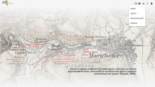
Research Project “Karten von Attica and GISc''
YEAR
2021
GRANTS
INNOVATION & SUSTAINABLE DEVELOPMENT

Bio3 – Biomedicine, Bioinformatics and Biotechnology Forum: Fostering Collaboration in Industry and Academia
BioInnovation Greece NPO

"Walk the Long Walls" Research Project
"DIPYLON" Society for the Study of Ancient Topography

Technology Entrepreneurship and Innovation Programmes
STARTSMART SEE

Business Incubator and Accelerator Programme for Female Enterpreneurship
EGG – ENTER•GROW•GO

Start-up Empowerment Programe 2023
IMPACT HUB ATHENS

Science and Technology Initiatives
Hellenic Institute of Advanced Studies (HIAS)

Research Programmes and Activities 2023
Research Centre for the Humanities (RCH)

“D-HUB” Incubator
"DIAZOMA" Association

“Protovoulia ‘21”: Climate Change and the Environment
PROGRAMME: “Protovoulia '21 ”

"Queen Rearing: Utilisation, Rescue and Genetic Improvement of Bees in the Region of Evia” Programme
NEW AGRICULTURE NEW GENERATION NPO

“Terra Graeca: Small Farm to Market” Programme
Mediterranean Institute for Nature and Anthropos – MEDINA
